Extreme Rain Rates Observed on June 19th 2002
Introduction
During the afternoon hours of 19 June 2002 a strong thunderstorm passed a few kilometers to the north of the CSU-CHILL radar site near Greeley, Colorado. While this storm produced up to approximately marble sized hailstones, its primary characteristic was very high rainfall rates.
At the time of the storm passage, the CSU-CHILL radar was operating in support of a small (20 hours of radar operating time) project under the direction of Profs. Bruce Lee and Cathy Finley at the University of Northern Colorado. The data collection procedures for this project were optimized for the observation of low level thunderstorm outflows. To provide rapid data updates, PPI sector scans were done at only two fairly shallow elevation angles. This resulted in volume scan time interval was approximately 90 seconds.
Rainfall Estimation Methods
Members of the CSU Atmospheric Science Department have developed techniques for estimating the instantaneous rainfall rate based on various dual polarization radar measurements (i.e., co-polar reflectivity at horizontal polarization (), differential reflectivity (), and specific propagation differential phase (KDP)). To apply these rain rate estimation techniques, the 6/19/2002 radar data were interpolated to a Cartesian network of grid points (horizontal mesh size of 250 m) at a height of 500 m above ground level. The color shading in the following animation depicts the diagnosed rain rates on this analysis grid. Localized rain rate maxima in excess of 250 mm per hour (10 inches per hour) can be seen. The spatial configuration of the rain rate fields also displays significant evolution even in these short time intervals.


|
|
||
|
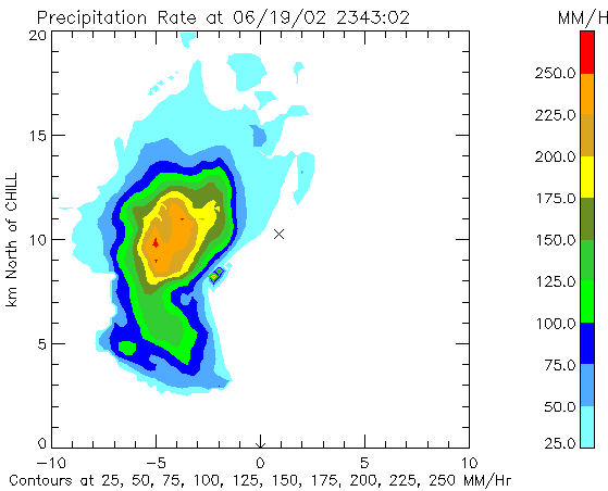
The following plot shows the rainfall total integrated from the rain rates observed between 2342 and 0014 UTC. The "X" symbol in these plots marks the location of a Mountain States Weather Services Co-operative weather spotter. This spotter observed 1.9 inches of rain during the storm passage. This heavy rain was accompanied by approximately 40 mph winds and enough small hail to cover the ground. It is suspected that the strong winds and possible clogging of the rain gage funnel by an accumulation of hailstones may have reduced the rain gage catch.


The photograph provides additional evidence of the locally heavy rainfall produced by this storm. This picture of extensive runoff was taken by Dr. Bruce Lee shortly after the storm's passage.