Development of hail and heavy rain signatures in a thunderstorm: 29 June 2007
Introduction
During the early hours (UTC) on 29 June 2007, the CSU-CHILL radar collected low elevation angle PPI scans over a narrow azimuth sector that was centered on an area of developing thunderstorms. This scanning procedure gave a volume scan cycle time of slightly less than one minute. The following image loops present a sequence of 10 0.5 degree elevation angle PPI images. During this time period, the differential reflectivity field develops a near 0 dB local minimum when hailstones descend into the scan plane.
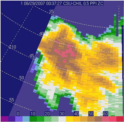
Reflectivity (dBZ)
Reflectivity levels exceeding ~60 dBZ begin to cross the 45 km range ring in the 5th image frame.
|
|
||
|
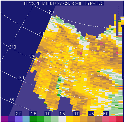
Differential Reflectivity ()

In concert with the advancing 60 dBZ echo core noted above, an area of ~0 dB values also starts to cross the 45 km range range in the 5th image frame. The quasi-random orientations of the hailstones act to equalize the received H and V co-polar signal levels. is an expression of the reflectivity-weighted mean axis ratio of the illuminated scatterers. Thus, the arrival of the highly reflective tumbling hailstones lowers the from the positive values associated with oblate raindrops to ~ 0dB in the hail region.
|
|
||
|
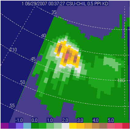
Specific Differential Propagation Phase ()

Despite the onset of hail, the specific differential propagation phase () values do not increase appreciably along the 45 km range ring. This is due to 's sensitivity to oriented, non-spherical hydrometeors (i.e., large raindrops), vs. its insensitivity to randomly oriented, nearly spherical particles like hailstones. Because of this behavior, -based rain rate estimators generally give more accurate results than reflectivity-based rain rate estimators when hail is present.
|
|
||
|