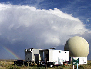
The CSU-CHILL Site primarily hosts the CSU-CHILL S-band weather radar, along with other guest instruments. CSU also operates a second S-band weather radar at the Pawnee site.
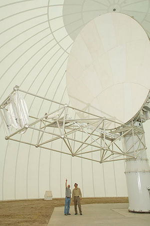
CSU-CHILL is a transportable dual-polarization radar system, with a 9 meter parabolic dual-offset reflector antenna. The radar features two S-band dual Klystron transmitters driving each polarization channel, and an X-band transmitter driving the two polarization channels. Each S-band transmitter develops approximately 1 MW of power, while the X-bands generate 25 kW. The transmitters are controlled by a flexible digital waveform generator, which can synthesize a wide variety of polarization states. The low-noise receivers are connected to a customized signal processing system, which can output various polarimetric moments. Moment data, as well as raw time series data can be archived for later study. The facility is connected to the CSU network through a high bandwidth microwave link, which provides up to 30 MBps data rate.
The radar site is located near Greeley, CO at latitude 40° 26' 46.5'' (N40.44625) and longitude 104° 38' 13.5'' (W104.63708), at an elevation of 1432 meters MSL.
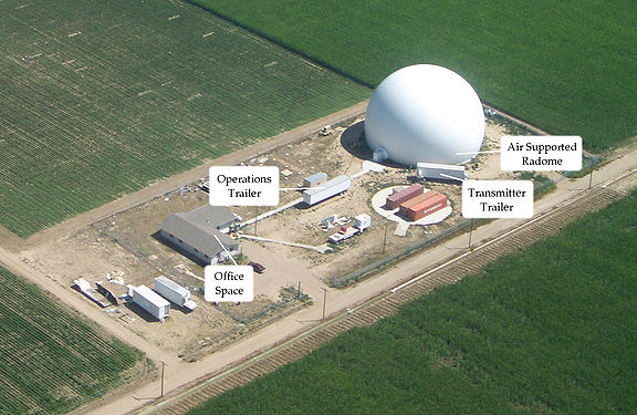
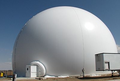
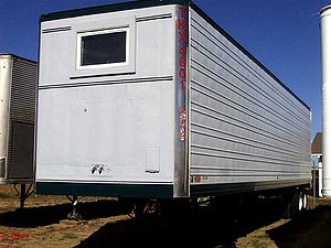
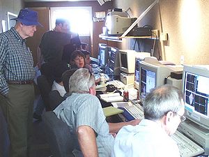
The antenna is housed within an inflatable radome, for protection against wind loading and corrsion. The radome is constructed from low-loss microwave-transparent materials. The main radar hardware is housed within the radar trailer, which contains the transmitters, receivers and control subsystems. The digitized signals from the receiver are passed through fiber-optic cables to the operations trailer, which contains the Parallel Receiver signal processor and display workstations.
These projects usually involve moving the radar, larger time scales of observation (typically in excess of 20 hours) and requires the involvement and funding from the National Science Foundation (NSF). Please contact the Scientific Director for details on requesting the use of the facility.
These are larger projects that do not involve funding from the National Science Foundation. A daily use fee will be charged during the data collection process. Please contact the Scientific Director for details on requesting the use of the facility.
20 hour projects were conceived as a method to provide simplified access to the radar for users with specific data collection requirements that can be supported with modest facility effort, typically, no more than ~20 hours of radar operational time. 20 hour project investigators (and often their students) also gain valuable experience in the overall planning and conduct of meteorological field research activities.
20 hour projects have secondary priority to the support of NSF-allocated research projects. Their support is also contingent upon scheduled radar maintenance/upgrade activities and facility staff availability. 20 hour project expenses are currently provided by the facility’s NSF base funding.
The CSU-Pawnee Doppler radar is a single-polarization S-band radar sysem, with a Klystron transmitter. It is located 48 km NNW of the CSU-CHILL radar. The radar system is used in a dual-doppler configuration along with CSU-CHILL, and can perform synchronized scans.
The radar transmitter frequency is 2.730 GHz, and uses a vertically polarized antenna with a 1.6° beamwidth. The signal processor used is the CHILL Parallel Receiver. The transmitter can generate an output power of 425 kW. The radar is located at latitude 40° 52.269' (N 40.87115) and longitude 104° 42.84' (W 104.714) , at an altitude of 1688 m MSL.
Some example cases of dual-doppler data collected with the CHILL-Pawnee dual-doppler network are presented in the Featured Analysis page.
The Front Range Observational Network Testbed (FRONT) is anchored by the CSU-CHILL and NCAR S-Pol NSF research radars. Very cost effective data collection can be done while these radars are at their home base locations (Greeley and Firestone CO respectively.) In conjunction with the neighboring NWS WSR-88D radars at Cheyenne, WY and Denver, CO, dual-polarization / multiple-Doppler radar coverage is available over a wide region that includes a variety of terrain complexity.
Loading map...
{"minzoom":false,"maxzoom":false,"mappingservice":"leaflet","width":"auto","height":"600px","centre":false,"title":"","label":"","icon":"","lines":[],"polygons":[{"text":"","title":"","link":"","strokeColor":"#B0920C","strokeOpacity":"1","strokeWeight":"2","pos":[{"lat":40.60814,"lon":-104.595451},{"lat":40.772286,"lon":-104.638294},{"lat":40.911367,"lon":-104.76085},{"lat":41.003999,"lon":-104.944693},{"lat":41.03587,"lon":-105.1616},{"lat":41.002043,"lon":-105.377985},{"lat":40.90776,"lon":-105.560347},{"lat":40.767588,"lon":-105.680706},{"lat":40.603072,"lon":-105.720987},{"lat":40.439338,"lon":-105.675619},{"lat":40.30122,"lon":-105.552047},{"lat":40.209537,"lon":-105.369294},{"lat":40.178046,"lon":-105.154943},{"lat":40.21146,"lon":-104.941084},{"lat":40.30478,"lon":-104.759737},{"lat":40.444003,"lon":-104.638288},{"lat":40.60814,"lon":-104.595451}],"onlyVisibleOnHover":false,"fillColor":"#B0920C","fillOpacity":"0.5"},{"text":"","title":"","link":"","strokeColor":"#B0920C","strokeOpacity":"1","strokeWeight":"2","pos":[{"lat":40.704893,"lon":-103.62826},{"lat":40.869381,"lon":-103.668784},{"lat":41.009474,"lon":-103.789483},{"lat":41.103637,"lon":-103.972231},{"lat":41.137321,"lon":-104.188986},{"lat":41.105309,"lon":-104.406189},{"lat":41.012557,"lon":-104.590205},{"lat":40.873397,"lon":-104.712786},{"lat":40.709225,"lon":-104.755506},{"lat":40.54512,"lon":-104.712416},{"lat":40.40598,"lon":-104.590628},{"lat":40.312781,"lon":-104.408905},{"lat":40.279507,"lon":-104.19469},{"lat":40.311137,"lon":-103.980053},{"lat":40.402936,"lon":-103.797125},{"lat":40.541132,"lon":-103.673518}],"onlyVisibleOnHover":false,"fillColor":"#B0920C","fillOpacity":"0.5"},{"text":"","title":"","link":"","strokeColor":"#F47E7D","strokeOpacity":"1","strokeWeight":"2","pos":[{"lat":40.113602,"lon":-103.909105},{"lat":40.258131,"lon":-103.945022},{"lat":40.381051,"lon":-104.050655},{"lat":40.46349,"lon":-104.210104},{"lat":40.492736,"lon":-104.398927},{"lat":40.464268,"lon":-104.587955},{"lat":40.382486,"lon":-104.747985},{"lat":40.260001,"lon":-104.854481},{"lat":40.11562,"lon":-104.891407},{"lat":39.971388,"lon":-104.853562},{"lat":39.849197,"lon":-104.74712},{"lat":39.767491,"lon":-104.588455},{"lat":39.738554,"lon":-104.401549},{"lat":39.766725,"lon":-104.214449},{"lat":39.847778,"lon":-104.055228},{"lat":39.96953,"lon":-103.947948},{"lat":40.113602,"lon":-103.909105}],"onlyVisibleOnHover":false,"fillColor":"#F47E7D","fillOpacity":"0.5"},{"text":"","title":"","link":"","strokeColor":"F47E7D","strokeOpacity":"1","strokeWeight":"2","pos":[{"lat":40.453959,"lon":-104.636977},{"lat":40.59825,"lon":-104.674631},{"lat":40.720492,"lon":-104.782128},{"lat":40.801913,"lon":-104.943277},{"lat":40.829956,"lon":-105.133368},{"lat":40.800288,"lon":-105.323027},{"lat":40.717495,"lon":-105.482954},{"lat":40.594345,"lon":-105.588633},{"lat":40.449745,"lon":-105.624166},{"lat":40.305771,"lon":-105.584572},{"lat":40.184271,"lon":-105.476294},{"lat":40.103582,"lon":-105.315979},{"lat":40.075831,"lon":-105.127851},{"lat":40.105182,"lon":-104.940131},{"lat":40.187234,"lon":-104.780985},{"lat":40.309653,"lon":-104.674471},{"lat":40.453959,"lon":-104.636977}],"onlyVisibleOnHover":false,"fillColor":"#F47E7D","fillOpacity":"0.5"},{"text":"","title":"","link":"","strokeColor":"#B5D045","strokeOpacity":"0.75","strokeWeight":"1.5","pos":[{"lat":39.725549,"lon":-104.540167},{"lat":39.889718,"lon":-104.582545},{"lat":40.028794,"lon":-104.703588},{"lat":40.121399,"lon":-104.885088},{"lat":40.153233,"lon":-105.09919},{"lat":40.119366,"lon":-105.312757},{"lat":40.025045,"lon":-105.492741},{"lat":39.884834,"lon":-105.611534},{"lat":39.720281,"lon":-105.651289},{"lat":39.556514,"lon":-105.60649},{"lat":39.418375,"lon":-105.484476},{"lat":39.326691,"lon":-105.304022},{"lat":39.295226,"lon":-105.092371},{"lat":39.32869,"lon":-104.881224},{"lat":39.422076,"lon":-104.702211},{"lat":39.561364,"lon":-104.582372},{"lat":39.725549,"lon":-104.540167}],"onlyVisibleOnHover":false,"fillColor":"#B5D045","fillOpacity":"0.35"},{"text":"","title":"","link":"","strokeColor":"#B5D045","strokeOpacity":"0.75","strokeWeight":"1.5","pos":[{"lat":40.182429,"lon":-103.778738},{"lat":40.346856,"lon":-103.819563},{"lat":40.486711,"lon":-103.939851},{"lat":40.580499,"lon":-104.121527},{"lat":40.613735,"lon":-104.336717},{"lat":40.58127,"lon":-104.552111},{"lat":40.488132,"lon":-104.734368},{"lat":40.348707,"lon":-104.855517},{"lat":40.184426,"lon":-104.897347},{"lat":40.020382,"lon":-104.854032},{"lat":39.881463,"lon":-104.732701},{"lat":39.788616,"lon":-104.552038},{"lat":39.755775,"lon":-104.339328},{"lat":39.787858,"lon":-104.126424},{"lat":39.88006,"lon":-103.94521},{"lat":40.018543,"lon":-103.823046},{"lat":40.182429,"lon":-103.778738}],"onlyVisibleOnHover":false,"fillColor":"#B5D045","fillOpacity":"0.35"},{"text":"","title":"","link":"","strokeColor":"#FB8335","strokeOpacity":"0.75","strokeWeight":"1.5","pos":[{"lat":41.069678,"lon":-104.056325},{"lat":41.180579,"lon":-104.084213},{"lat":41.274928,"lon":-104.166311},{"lat":41.338266,"lon":-104.290232},{"lat":41.360852,"lon":-104.437009},{"lat":41.339206,"lon":-104.584036},{"lat":41.276662,"lon":-104.708668},{"lat":41.182839,"lon":-104.791824},{"lat":41.072118,"lon":-104.82095},{"lat":40.961396,"lon":-104.791872},{"lat":40.867488,"lon":-104.709271},{"lat":40.804596,"lon":-104.585828},{"lat":40.782199,"lon":-104.440233},{"lat":40.803667,"lon":-104.294396},{"lat":40.865769,"lon":-104.170267},{"lat":40.959146,"lon":-104.086633},{"lat":41.069678,"lon":-104.056325}],"onlyVisibleOnHover":false,"fillColor":"#FB8335","fillOpacity":"0.35"},{"text":"","title":"","link":"","strokeColor":"#FB8335","strokeOpacity":"0.75","strokeWeight":"1.5","pos":[{"lat":40.950965,"lon":-104.699077},{"lat":41.061711,"lon":-104.727995},{"lat":41.155602,"lon":-104.810866},{"lat":41.218248,"lon":-104.93518},{"lat":41.240014,"lon":-105.081906},{"lat":41.217546,"lon":-105.228444},{"lat":41.154308,"lon":-105.352229},{"lat":41.060023,"lon":-105.434312},{"lat":40.949142,"lon":-105.462308},{"lat":40.838583,"lon":-105.432214},{"lat":40.745136,"lon":-105.348863},{"lat":40.682932,"lon":-105.225047},{"lat":40.661346,"lon":-105.079505},{"lat":40.683625,"lon":-104.934142},{"lat":40.74642,"lon":-104.810837},{"lat":40.840263,"lon":-104.728256},{"lat":40.950965,"lon":-104.699077}],"onlyVisibleOnHover":false,"fillColor":"#FB8335","fillOpacity":"0.35"},{"text":"","title":"","link":"","strokeColor":"#FF0000","strokeOpacity":"1","strokeWeight":"2","pos":[],"onlyVisibleOnHover":false,"fillColor":"#FF0000","fillOpacity":"0.5"}],"circles":[],"rectangles":[],"copycoords":false,"static":false,"zoom":false,"defzoom":14,"layers":["OpenStreetMap"],"image layers":[],"overlays":[],"resizable":false,"fullscreen":false,"scrollwheelzoom":true,"cluster":false,"clustermaxzoom":20,"clusterzoomonclick":true,"clustermaxradius":80,"clusterspiderfy":true,"geojson":"","clicktarget":"","imageLayers":[],"locations":[{"text":"\u003Cb\u003E\u003Cdiv class=\"mw-parser-output\"\u003E\u003Cp\u003E\u003Ca class=\"mw-selflink-fragment\" href=\"#CSU-CHILL\"\u003ECSU-CHILL\u003C/a\u003E\n\u003C/p\u003E\u003C/div\u003E\u003C/b\u003E\u003Cdiv class=\"mw-parser-output\"\u003E\u003Cfigure typeof=\"mw:File/Thumb\"\u003E\u003Ca href=\"/w/File:CHILL_Radome.jpg\" class=\"mw-file-description\"\u003E\u003Cimg src=\"/images/thumb/0/0b/CHILL_Radome.jpg/100px-CHILL_Radome.jpg\" decoding=\"async\" width=\"100\" height=\"67\" class=\"mw-file-element\" srcset=\"/images/thumb/0/0b/CHILL_Radome.jpg/150px-CHILL_Radome.jpg 1.5x, /images/thumb/0/0b/CHILL_Radome.jpg/200px-CHILL_Radome.jpg 2x\" /\u003E\u003C/a\u003E\u003Cfigcaption\u003E\u003C/figcaption\u003E\u003C/figure\u003E\u003Cp\u003ES- and X-band Dual Polarization, Dual Wavelength\u003C/p\u003E\u003C/div\u003E","title":"CSU-CHILL\n","link":"","lat":40.44625,"lon":-104.63708,"icon":""},{"text":"\u003Cb\u003E\u003Cdiv class=\"mw-parser-output\"\u003E\u003Cp\u003E\u003Ca class=\"mw-selflink-fragment\" href=\"#CSU-Pawnee\"\u003ECSU-Pawnee\u003C/a\u003E\n\u003C/p\u003E\u003C/div\u003E\u003C/b\u003E\u003Cdiv class=\"mw-parser-output\"\u003E\u003Cfigure typeof=\"mw:File/Thumb\"\u003E\u003Ca href=\"/w/File:Pawnee_Radar.jpg\" class=\"mw-file-description\"\u003E\u003Cimg src=\"/images/thumb/1/19/Pawnee_Radar.jpg/100px-Pawnee_Radar.jpg\" decoding=\"async\" width=\"100\" height=\"76\" class=\"mw-file-element\" srcset=\"/images/thumb/1/19/Pawnee_Radar.jpg/150px-Pawnee_Radar.jpg 1.5x, /images/thumb/1/19/Pawnee_Radar.jpg/200px-Pawnee_Radar.jpg 2x\" /\u003E\u003C/a\u003E\u003Cfigcaption\u003E\u003C/figcaption\u003E\u003C/figure\u003E\u003Cp\u003ES-band Vertical polarization\u003C/p\u003E\u003C/div\u003E","title":"CSU-Pawnee\n","link":"","lat":40.870868,"lon":-104.714593,"icon":""},{"text":"\u003Cb\u003E\u003Cdiv class=\"mw-parser-output\"\u003E\u003Cp\u003E\u003Ca rel=\"nofollow\" class=\"external text\" href=\"https://www.eol.ucar.edu/instrumentation/remote-sensing/s-pol\"\u003ENCAR S-PolKa\u003C/a\u003E\n\u003C/p\u003E\u003C/div\u003E\u003C/b\u003E\u003Cdiv class=\"mw-parser-output\"\u003E\u003Cfigure typeof=\"mw:File/Thumb\"\u003E\u003Ca href=\"/w/File:S-pol_at_firestone.jpg\" class=\"mw-file-description\"\u003E\u003Cimg src=\"/images/thumb/c/c7/S-pol_at_firestone.jpg/100px-S-pol_at_firestone.jpg\" decoding=\"async\" width=\"100\" height=\"66\" class=\"mw-file-element\" srcset=\"/images/thumb/c/c7/S-pol_at_firestone.jpg/150px-S-pol_at_firestone.jpg 1.5x, /images/thumb/c/c7/S-pol_at_firestone.jpg/200px-S-pol_at_firestone.jpg 2x\" /\u003E\u003C/a\u003E\u003Cfigcaption\u003E\u003C/figcaption\u003E\u003C/figure\u003E\u003Cp\u003E S- and Ka-band Dual Polarization\u003C/p\u003E\u003C/div\u003E","title":"NCAR S-PolKa\n","link":"","lat":40.12333,"lon":-104.891333,"icon":""},{"text":"\u003Cb\u003E\u003Cdiv class=\"mw-parser-output\"\u003E\u003Cp\u003EKFTG\n\u003C/p\u003E\u003C/div\u003E\u003C/b\u003E\u003Cdiv class=\"mw-parser-output\"\u003E\u003Cfigure typeof=\"mw:File/Thumb\"\u003E\u003Ca href=\"/w/File:LabNexrad.jpg\" class=\"mw-file-description\"\u003E\u003Cimg src=\"/images/thumb/2/2b/LabNexrad.jpg/100px-LabNexrad.jpg\" decoding=\"async\" width=\"100\" height=\"80\" class=\"mw-file-element\" srcset=\"/images/thumb/2/2b/LabNexrad.jpg/150px-LabNexrad.jpg 1.5x, /images/thumb/2/2b/LabNexrad.jpg/200px-LabNexrad.jpg 2x\" /\u003E\u003C/a\u003E\u003Cfigcaption\u003E\u003C/figcaption\u003E\u003C/figure\u003E\u003Cp\u003EDenver NEXRAD S-band Dual Polarization\u003C/p\u003E\u003C/div\u003E","title":"KFTG\n","link":"","lat":39.7866666666667,"lon":-104.545833333333,"icon":""},{"text":"\u003Cb\u003E\u003Cdiv class=\"mw-parser-output\"\u003E\u003Cp\u003EKCYS\n\u003C/p\u003E\u003C/div\u003E\u003C/b\u003E\u003Cdiv class=\"mw-parser-output\"\u003E\u003Cfigure typeof=\"mw:File/Thumb\"\u003E\u003Ca href=\"/w/File:LabNexrad.jpg\" class=\"mw-file-description\"\u003E\u003Cimg src=\"/images/thumb/2/2b/LabNexrad.jpg/100px-LabNexrad.jpg\" decoding=\"async\" width=\"100\" height=\"80\" class=\"mw-file-element\" srcset=\"/images/thumb/2/2b/LabNexrad.jpg/150px-LabNexrad.jpg 1.5x, /images/thumb/2/2b/LabNexrad.jpg/200px-LabNexrad.jpg 2x\" /\u003E\u003C/a\u003E\u003Cfigcaption\u003E\u003C/figcaption\u003E\u003C/figure\u003E\u003Cp\u003ECheyenne NEXRAD S-band Dual Polarization\u003C/p\u003E\u003C/div\u003E","title":"KCYS\n","link":"","lat":41.1519444444444,"lon":-104.806111111111,"icon":""}],"imageoverlays":null}
The CSU-CHILL site is also host to guest instrumentation from other organizations.
The CSU-CHILL site provides high-bandwidth network connectivity (25 Mbit) through a wireless link. The link terminates at the University of Northern Colorado, which provides high-bandwidth connectivity via optic fiber to the CSU main campus.
In addition to the radar and remote sensing equipment, the CSU-CHILL facility also hosts an RF Instrument Lab, which is used by both CHILL staff as well as CSU students during construction and maintenance of the radar equipment.
![]() CSU-CHILL Technical Brochure
CSU-CHILL Technical Brochure  . A more detailed description of the hardware and software architecture of CHILL is given in the hardware description.
