Dual frequency observations of a dry cold front: 15 August 2012
Author: P. C. Kennedy

Radial velocity data collected by the CSU-CHILL radar at S-band as a dry (precipitation-free) cold front approached the radar site from the northeast on 15 August 2012. The radar was also recording high-resolution X-Band observations during this frontal passage. Time lapse loops of selected data fields have been assembled.
Introduction
During the mid-day hours of 15 August 2012 a cold front which produced no precipitation and minimal cloud development passed the CSU-CHILL radar site while propagating towards the southwest. As the front approached, the CSU-CHILL radar was operated in dual frequency (3 GHz / S-Band and 9 GHz / X-Band) mode. To provide high temporal resolution, the antenna executed only a single 360 deg PPI scan at an elevation of 1 degree followed by two RHI sweeps aimed at the approaching front on azimuths of 10 degrees (elevation angle moving up) and 39 degrees (elevation moving down). This scan pattern gave a cycle time of ~2:20.
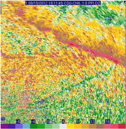
X-Band reflectivity loop
The reflectivity data collected at X-Band in the PPI scans is shown in the following loop. Convergence along the leading edge of the cold front enhanced the concentration of insects and debris raised from the surface, contributing to a thin band of maximized reflectivity. The advancing front also intersected a pre-existing boundary layer echo line; this collision appeared to generate a localized cyclonic vorticity maxima. To the rear of the front, the spatial reflectivity patterns showed indications of both open cellular and horizontal roll patterns as the thermal stability and wind shear structure changed in the post-frontal airmass. The narrow (0.3 deg) X-band antenna pattern and small (75 m) range depth in the X-band data improved the resolution of these echo features. (The fixed, narrow wedge of diminished reflectivities is due to partial beam blockage from ground objects located to the northeast of the radar).
|
|
||
|
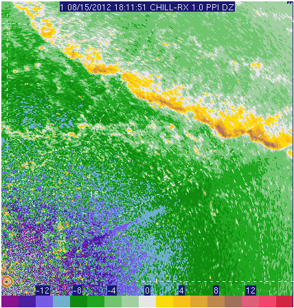
S-Band reflectivity loop
The following loop shows the corresponding S-Band reflectivity images. Due to the 1 deg antenna pattern beam width and the 150 m range gate depth, the echo patterns are more coarse at S-Band vs. X-Band. The S-band reflectivities are appreciably stronger than those at X-Band due to the larger Bragg scattering contribution at S-band.
|
|
||
|
X-Band RHI data
The vertical structure of the frontal echo is shown in the following plots of X-band data fields collected in a 039 degree azimuth RHI scan. In the next two plots, the color-filled field is the de-aliased radial velocity data. The velocity pattern suggests that the cold air propagated along the surface as a gravity current which deepened into a rotating head structure at the leading edge. Similar airflow patterns in a dry cold front have been reported by Fredrich et. al. (MWR 2008, p3796-3821; Fig. 17). The shape of the overlain reflectivity contours suggests that the frontal roll circulation was sweeping scatterers up from near-surface heights.

The following plot shows the same radial velocity pattern overlain by the 4 dB Zdr contour. The combination of significantly positive Zdr values and low reflectivity levels implies that backscattering from insects was a significant contribution to the frontal band echo.

The final plot shows the X-band rhoHV field scaled up by a factor of 10. (To suppress noise contributions, these data were thresholded at the -1 dBZ level which is ~9 dB above the noise level at a range of 20 km). The correlation magnitudes are generally below 0.8 (8 in the scaled plot), which is in agreement with the rhoHV levels reported for surface debris lofted by tornadoes (Ryzhkov el at JCAM 2005, 557-570).

Summary
The high spatial resolution X-band data made available the 8.5 m diameter dual offset feed antenna allowed the observation of detailed features in Doppler and dual-polarization fields associated with a dry cold frontal passage.