Template:Featured Article/November, 2014: Difference between revisions
From CSU-CHILL
Pat kennedy (talk | contribs) (Corrected bad link) |
m (Fixed article link) |
||
| Line 1: | Line 1: | ||
[[Image:1oct2014 2029 NWS vr anot.png|300px|right]] | [[Image:1oct2014 2029 NWS vr anot.png|300px|right]] | ||
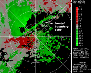
CSU-CHILL radial velocity data in a low elevation angle surveillance scan taken as a well-defined cold front approached the radar site from the northwest on 1 October 2014. Time lapse loops of the reflectivity and radial velocity data recorded during this frontal passage have been assembled. | CSU-CHILL radial velocity data in a low elevation angle surveillance scan taken as a well-defined cold front approached the radar site from the northwest on 1 October 2014. Time lapse loops of the reflectivity and radial velocity data recorded during this frontal passage have been assembled. | ||
('''[[DPWX/ | ('''[[DPWX/Cold frontal passage at the CSU-CHILL radar site: 1 October 2014|Full Article...]]''') | ||
Latest revision as of 16:55, 10 November 2014

CSU-CHILL radial velocity data in a low elevation angle surveillance scan taken as a well-defined cold front approached the radar site from the northwest on 1 October 2014. Time lapse loops of the reflectivity and radial velocity data recorded during this frontal passage have been assembled. (Full Article...)