(14 intermediate revisions by the same user not shown)
Line 1:
Line 1:
The CSU-CHILL Site primarily hosts the CSU-CHILL S-band weather radar, along with other guest instruments. CSU also operates a second S-band weather radar at the Pawnee site.
CSU-CHILL is spread across multiple sites, and comprises a number of weather radar systems, laboratory and workshop space.
==CSU-CHILL==
==Weather Radars==
CSU-CHILL is a transportable dual-polarization radar system, with a 9 meter parabolic dual-offset reflector antenna. The radar features two S-band [[CHILL Transmitters|dual Klystron transmitters]] driving each polarization channel, and an X-band transmitter driving the two polarization channels. Each S-band transmitter develops approximately 1 MW of power, while the X-bands generate 25 kW. The transmitters are controlled by a flexible digital waveform generator, which can synthesize a wide variety of polarization states. The [[CHILL Receivers|low-noise receivers]] are connected to a [[CHILL Signal Processor|customized signal processing system]], which can output various polarimetric moments. Moment data, as well as raw time series data can be archived for later study. The facility is connected to the CSU network through a [[Wireless Link|high bandwidth microwave link]], which provides up to 30 MBps data rate.
===[[CSU-CHILL S- and X-band|CSU-CHILL]]===
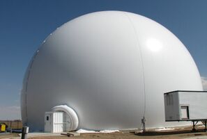
[[Image:CHILL Radome.jpg|x200px|left|thumb|The CSU-CHILL Radar |link=CSU-CHILL S- and X-band]]
[[Image:Sea pol small.jpg|x300px|left|thumb|The CSU Sea-Pol Radar|link=Sea-Pol]]
{{#lst:Sea-Pol|overview}}
The radar site is located near Greeley, CO at latitude <nowiki>40° 26' 46.5'' (N40.44625) and longitude 104° 38' 13.5'' (W104.63708)</nowiki>, at an elevation of 1432 meters MSL.
This is a pair of [[X-band containerized radar|X-band containerized radars]] designed for rapid deployment to remote locations. They feature 25 kW magnetron transmitters, with 1.6m antennas (1.3° beamwidth).
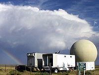
[[Image:CHILL Radome.jpg|center|400px|thumb|CHILL Radome and Airlock]]
<br clear=all>
===Miami W-band===
The [[Miami W-band]] radar is a vertically-pointing, containerized W-band cloud radar system, operated along with the [https://psl.noaa.gov/ NOAA Physical Science Laboratory]. It has a 1.2 kW Extended Interaction Klystron (EIK) transmitter. It has a number of antenna options, including 0.9m (0.25° beamwidth).
The antenna is housed within an inflatable radome, for protection against wind loading and corrsion. The radome is constructed from low-loss microwave-transparent materials. The main radar hardware is housed within the radar trailer, which contains the transmitters, receivers and control subsystems. The digitized signals from the receiver are passed through fiber-optic cables to the operations trailer, which contains the Parallel Receiver signal processor and display workstations.
<br clear=all>
===PSL W-band===
The [[PSL W-band]] radar is a vertically-pointing, containerized W-band cloud radar system, operated along with the [https://psl.noaa.gov/ NOAA Physical Science Laboratory]. It has a 1.2 kW Extended Interaction Klystron (EIK) transmitter. It has a 0.3m (1° beamwidth) antenna, and is designed for deployment on NOAA P3 research aircraft.
[[CSU/NASA D3R]] is a dual-wavelength Ku- and Ka-band radar featuring solid-state transmitters and pulse compression receivers. It is trailer-mounted for ease of transportation. It is based at the [https://www.nasa.gov/wallops/ NASA Wallops Flight Facility].
===Requesting Use of the Facility===
<br clear=all>
Projects conducted at the facility can be classified into
These projects usually involve moving the radar, larger time scales of observation (typically in excess of 20 hours) and requires the involvement and funding from the National Science Foundation (NSF). Please [[Contacts|contact the Scientific Director]] for details on requesting the use of the facility.
{{#lst:FrontX|overview}}
====Cost-recovery====
<br clear=all>
These are larger projects that do not involve funding from the National Science Foundation. A daily use fee will be charged during the data collection process. Please [[Contacts|contact the Scientific Director]] for details on requesting the use of the facility.
20 hour projects were conceived as a method to provide simplified access to the radar for users with specific data collection requirements that can be supported with modest facility effort, typically, no more than ~20 hours of radar operational time. 20 hour project investigators (and often their students) also gain valuable experience in the overall planning and conduct of meteorological field research activities.
20 hour projects have secondary priority to the support of NSF-allocated research projects. Their support is also contingent upon scheduled radar maintenance/upgrade activities and facility staff availability. 20 hour project expenses are currently provided by the facility’s NSF base funding.
===[[CSU Pawnee S-band]]===
{{#lst:CSU Pawnee S-band|overview}}
To request a 20-hour project, please Fill out the [https://docs.google.com/a/rams.colostate.edu/spreadsheet/embeddedform?formkey=dEN2ODlYaE1HenYzdHFyMDZLNGw2M2c6MQ Small project application form].
==Locations==
CSU-CHILL currently administers two permanent sites in Colorado
* [[CSU-CHILL main site]], Greeley CO
* [[ARDEC South radar site]], Fort Collins CO
===Technical Documentation===
==Lab Facilities==
Technical details of the CHILL radar are described in the {{pdf|brochure_web.pdf|CSU-CHILL Technical Brochure}}. A more detailed description of the hardware and software architecture of CHILL is given in the [[hardware description]].
In addition to the radar and remote sensing equipment, the CSU-CHILL facility also hosts an [[RF Instrument Lab]], which is used by both CHILL staff as well as CSU students during construction and maintenance of the radar equipment.
==CSU-Pawnee==
The CSU-Pawnee Doppler radar is a single-polarization S-band radar sysem, with a Klystron transmitter. It is located 48 km NNW of the CSU-CHILL radar. The radar system is used in a dual-doppler configuration along with CSU-CHILL, and can perform synchronized scans.
The radar transmitter frequency is 2.730 GHz, and uses a vertically polarized antenna with a 1.6° beamwidth. The signal processor used is the CHILL Parallel Receiver. The transmitter can generate an output power of 425 kW. The radar is located at latitude <nowiki>40° 52.269' (N 40.87115) and longitude 104° 42.84' (W 104.714) </nowiki>, at an altitude of 1688 m MSL.
Some example cases of dual-doppler data collected with the CHILL-Pawnee dual-doppler network are presented in the Featured Analysis page.
==FRONT==
The Front Range Observational Network Testbed (FRONT) is anchored by the CSU-CHILL and NCAR S-Pol NSF research radars. Very cost effective data collection can be done while these radars are at their home base locations (Greeley and Firestone CO respectively.) In conjunction with the neighboring NWS WSR-88D radars at Cheyenne, WY and Denver, CO, dual-polarization / multiple-Doppler radar coverage is available over a wide region that includes a variety of terrain complexity.
{{#display_map:
40.44625,-104.63708~[[Facilities#CSU-CHILL|CSU-CHILL]]~[[Image:CHILL_Radome.jpg|thumb|100px]]S- and X-band Dual Polarization, Dual Wavelength;
The CHILL main site includes a workshop with a variety of tooling and hardware.
==Guest Instrumentation==
==Electronic Design and CAD Software==
The CSU-CHILL site is also host to guest instrumentation from other organizations.
CSU-CHILL has licenses for several electronic design automation (EDA) and computer aided design (CAD) packages, including:
===NCAR Weather Station===
* MathWorks Matlab
===UPRM X-band===
* Keysight Advanced Design System (ADS)
===NASA D3R===
* Keysight Genesys
* Keysight SystemVue
* Altium Designer
* Solidworks
* Xilinx Vivado and ISE
==Network Connectivity==
In addition, students at CSU-CHILL have access to software offered by the CSU Electrical and Computer Engineering department.
The CSU-CHILL site provides high-bandwidth network connectivity (25 Mbit) through a [[Wireless Link|wireless link]]. The link terminates at the University of Northern Colorado, which provides high-bandwidth connectivity via optic fiber to the CSU main campus.
The CSU-Pawnee site uses an DSL line (512 kbit) provided by the [http://www.nunntel.com/ Nunn Telephone Company].
==Lab Facilities==
In addition to the radar and remote sensing equipment, the CSU-CHILL facility also hosts an [[RF Instrument Lab]], which is used by both CHILL staff as well as CSU students during construction and maintenance of the radar equipment.
Latest revision as of 17:54, 6 February 2024
CSU-CHILL is spread across multiple sites, and comprises a number of weather radar systems, laboratory and workshop space.
CSU-CHILL S- and X-band is a dual-wavelength S- and X-band, dual polarization scanning radar system located at the CSU-CHILL main site. The S-band transmitter can be selected between dual 1 MW Klystron transmitters or solid-state 24 kW transmitters. The X-band transmitter is a 25 kW magnetron. The antenna is an 8.5m dual-offset (1° at S-band, 0.3° at X-band).
The radar in its current form is designed to provide very high purity polarimetric data thanks to its unique offset-feed antenna design. The dual-wavelength capability with S- and X-band simultaneous operation is unique in the research radar community. The radar offers high spatial resolution at X-band thanks to the combination of short wavelength and large aperture antenna.
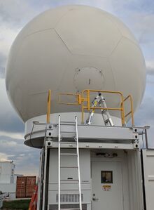
The CSU Sea-Pol ship- and land-deployable radar measures dual-polarization data over a range in excess of 200 km. It is designed for operation aboard Global-class research ships operated by the US oceanographic community, and has also been successfully operated on land-based deployments. The radar operates at C-band (5.65 GHz) and has a 4.3m stabilized antenna system.
The radar features dynamic platform stabilization, allowing it to perform earth-relative scanning strategies even on a moving platform such as a ship on the open ocean. A state of the art RVP900 digital signal processor outputs dual-polarization moment data, and provides the IRIS radar user interface.
The radar is packaged into two sub-assemblies, the radar shelter and the antenna platform. The radar shelter is housed in a 20' ISO container for ease of transportation and mounting onto research ships. The antenna platform is designed to mate to the top of the radar shelter, and holds the antenna positioner, antenna and radome.
CSU Sea-Pol is a part of the National Science Foundation's Community Instruments and Facilities Program, and may be requested through that program. When not deployed in the field, the radar is based at the CSU-CHILL main site in Greeley CO.
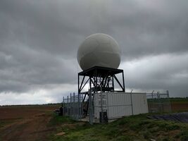
CSU-CHIVO is a C-band radar system with a 250 kW magnetron transmitter and a 4.5m (1° beamwidth) antenna. The antenna and radome are on top of a 6.5m (20 ft) steel tower to raise it above surrounding ground clutter. It is packaged in a containerized format for ease of transportation.
The radar is based on the Vaisala WRM200 commercial weather radar system. It is normally based at the ARDEC South radar site near Fort Collins, CO where it supports research scientists at Colorado State University. In 2019, it was used by the National Weather Service office in Boulder, CO as a gap-filler during an extended servicing of the NWS Denver NEXRAD (KFTG). The radar has been deployed several times in support of field campaigns as well.
SPLASH/SAIL
This is a pair of X-band containerized radars designed for rapid deployment to remote locations. They feature 25 kW magnetron transmitters, with 1.6m antennas (1.3° beamwidth).
Miami W-band
The Miami W-band radar is a vertically-pointing, containerized W-band cloud radar system, operated along with the NOAA Physical Science Laboratory. It has a 1.2 kW Extended Interaction Klystron (EIK) transmitter. It has a number of antenna options, including 0.9m (0.25° beamwidth).
PSL W-band
The PSL W-band radar is a vertically-pointing, containerized W-band cloud radar system, operated along with the NOAA Physical Science Laboratory. It has a 1.2 kW Extended Interaction Klystron (EIK) transmitter. It has a 0.3m (1° beamwidth) antenna, and is designed for deployment on NOAA P3 research aircraft.
CSU/NASA D3R
CSU/NASA D3R is a dual-wavelength Ku- and Ka-band radar featuring solid-state transmitters and pulse compression receivers. It is trailer-mounted for ease of transportation. It is based at the NASA Wallops Flight Facility.
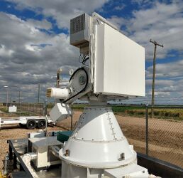
Front-X is an X-band dual-polarization phased array radar demonstrator radar. The objective of this radar system is to demonstrate dual-polarization capability and to study the limits of phased array antennas on polarization measurements. The radar is a test-bed to validate new radar waveforms, pulsing schemes, signal processing algorithms and scanning strategies that take advantage of electronic beam steering. The radar was developed in partnership with FirstRF corp.
The radar consists of an X-band dual-polarization active phased array antenna that generates a fixed beam in one axis and can scan electronically in the other axis. The antenna array is composed of 64 radiating elements, each driving a patch array antenna that develops a fixed pattern 2.6° wide. Beam width is 1.5°x2.6°, with over 90° electronic scan range. Transmit peak power is 70 W, with a duty cycle up to 33%. Antenna polarization is switched between horizontal and vertical on an alternating basis. The antenna instantaneous bandwidth is 30 MHz tunable over the 9.21 - 9.61 GHz frequency range.
The CSU-Pawnee Doppler radar was a single-polarization S-band radar system, with a Klystron transmitter. It was decomissioned in March 2015. It was located 48 km NNW of the CSU-CHILL radar. The radar system was used in a dual-doppler configuration along with CSU-CHILL, and performed synchronized scans.
Locations
CSU-CHILL currently administers two permanent sites in Colorado
In addition to the radar and remote sensing equipment, the CSU-CHILL facility also hosts an RF Instrument Lab, which is used by both CHILL staff as well as CSU students during construction and maintenance of the radar equipment.
The CHILL main site includes a workshop with a variety of tooling and hardware.
Electronic Design and CAD Software
CSU-CHILL has licenses for several electronic design automation (EDA) and computer aided design (CAD) packages, including:
MathWorks Matlab
Keysight Advanced Design System (ADS)
Keysight Genesys
Keysight SystemVue
Altium Designer
Solidworks
Xilinx Vivado and ISE
In addition, students at CSU-CHILL have access to software offered by the CSU Electrical and Computer Engineering department.