An example of reflectivity-based rain rate over-estimation due to ice hydrometeor contamination on 18 August 2009
Introduction
Historically, the measured radar reflectivity factor (Z) has been used to estimate the instantaneous rainfall rate. In developing these R(Z) relationships, it is assumed that a population of liquid raindrops is responsible for the backscattered signal received by the radar. This assumption is compromised when the pulse volume also contains frozen hydrometeors. Freely falling raindrops generally become unstable and breakup as their diameters exceed ~8 mm. In contrast, the ice structure of graupel pellets and hailstones allows them to maintain much larger diameters. Since the strength of the backscattered signal is a strong function of the diameter of the scattering particle, the presence of frozen hydrometeors in the pulse volume generally increases reflectivity. (This is especially true when the ice particles are undergoing melting and their refractive index values approach that of water.) As a result, the rain rate calculated from the reflectivity factor is generally overestimated when ice particles “contaminate” the raindrop population. An example of this effect was observed by the CSU-CHILL radar on 18 August 2009.
Reflectivity
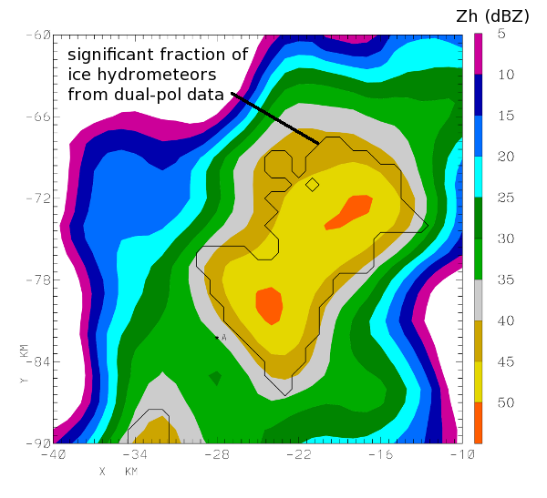
The following plot shows the radar reflectivity data recorded in a 0.6 degree PPI sweep made at 1920 UTC. (To aid in contour plotting, the data have been interpolated to a 1 km X, Y Cartesian grid on the PPI scan surface. A 2-D horizontal smoother has been applied to the gridded data.) The single black contour line encloses gridpoints where a fuzzy logic particle identification procedure has inferred the presence of a significant frozen hydrometeor component.

R(Z) Rain Rate
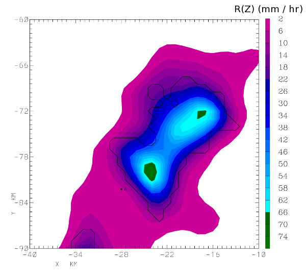
Rain rates calculated from the basic reflectivity data are shown below. This calculation was done using the standard NWS / WSR-88D equation:
(R in mm/hr, Z in ; with the maximum Z value clamped at the linear scale equivalent of 53 dBZ)
For reference, this formula yields a rain rate of 63 for a reflectivity factor of 50 dBZ.

Specific Differential Propagation Phase
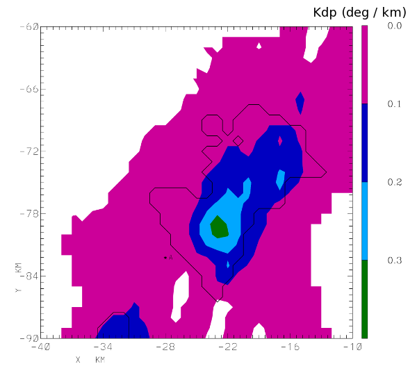
Dual polarization radars can make measurements that are more directly associated with the raindrop component of the scatters in the pulse volume. One such measurement is specific differential propagation phase (Kdp). Kdp is the rate at which the phase difference between the horizontally and vertically polarized received signals changes per km range interval along the beam path. In areas where a high concentration of oblate particles exist (i.e., large raindrops), the phase of the horizontally-polarized (H) radar pulse will increasingly lag that of the V pulse. Ice particles are generally more spherically shaped than large raindrops and they typically do not maintain predictable orientations as they fall. Due to these factors, the frozen hydrometeor component in convective rain minimally affects Kdp. The Kdp values developed using the CSU DROPS (Dualpol Radar Operational Products System) procedures are shown in the next plot. In this case, the Kdp magnitudes are only a fraction of a degree / km, indicating that only a limited portion of the backscattered signal amplitude is due to oblate particles (raindrops).

R(Kdp)
Various power law relationships have been developed to estimate rain rate from Kdp. The final plot shows such rain rates calculated from:
(Kdp is one way differential propagation phase shift in )
These phase-based rain rates are generally under 20 mm / hr. In this example, the reflectivity enhancement due to the ice contamination in much of the echo core has caused the reflectivity-based rain rates to be approximately 3 times greater than the rates calculated from Kdp. This reduced susceptibility to ice contamination effects is one of the primary advantages in the use of dual polarization radar technology for the remote sensing of rainfall.


